The EU-funded ODYSSEA project held the third annual session in its Summer School series online on 23-27 November 2020, titled “Satellite Observations & Data Processing in Operational Oceanography”, and focusing on “the synergy between satellite observations of the sea surface and in situ measurements,” organisers said. The programme drew some 120 young professional trainees from 28 countries, especially from the Southern Mediterranean.
The objective of this latest ODYSSEA training session, part of ODYSSEA’s capacity building package managed by partner Special Protected Areas Regional Activity Center (SPA/RAC), was to familiarize students with existing satellite products, and how to use them together with in-situ data “in synergy”, to develop marine research approaches based on integrating data from multiple sources.
Particular focus was placed on the Sentinel Satellites ocean observation system, and studying the utility of each sensor and the bio-geophysical parameters that they provide, and on reinforcing the trainees’ capacity to apply and develop tools for analysing satellite observations and interpreting them alongside in-situ data and numerical model outputs available on the ODYSSEA platform.
“Satellite observations are essential to monitor and study the oceans dynamic and water quality. They provide an unmatched spatial and temporal coverage of such key oceanic variables as sea surface temperature and salinity, sea level, ocean colour, surface winds and even floating debris distribution,” said ODYSSEA coordinator Prof. Georgios Sylaios from the Democritus University of Thrace.
Sylaios added, that ocean satellite data has the further advantage of being freely available on the web for researchers. Combining the satellite data with in situ observations allows for crucial validation and calibration of the data and forecasts, enhancing their accuracy.
“A sustainable blue economy (reconciling marine resources protection and exploitation) requires enhancing the capacity of young marine scientists on real-time monitoring and operational prognostic modelling, in order to be able to assess objectively the environmental status and help in marine spatial planning strategies and in decision-making,” Slim Gana from SPA/RAC explained. “On top of that, the volume of data concerning the marine environment collected both by satellites and on-site monitoring instruments is becoming more and more enormous. All these data need to be retrieved, processed, interpreted and then fed into numerical models for reanalysis and forecasting by skilled observatories scientists, focusing on different areas of the Mediterranean.”
Participants in the programme received training in:
- Understanding satellite sensor measurement principles and the environmental observations they provide;
- Retrieving and using oceanographic datasets, especially satellites and numerical models’ output, and exploring international databases on the marine environment;
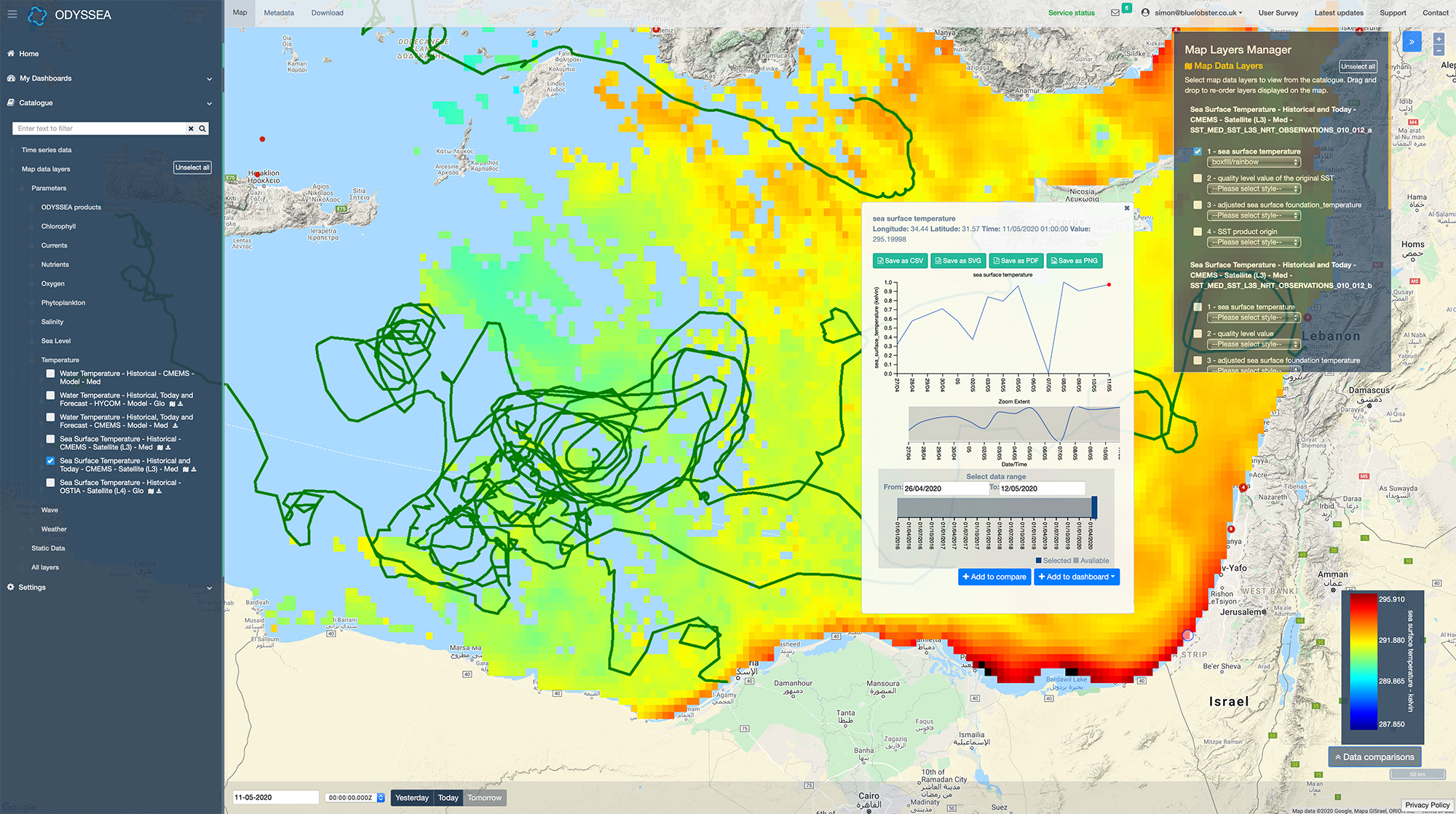
- Using the ODYSSEA project platform for retrieving, managing and processing oceanographic, environmental and satellite data of the Mediterranean Sea, along with other processing tools;
- Understanding data calibration and validation procedures;
- Understanding how satellite data are assimilated into numerical models;
- Using the knowledge that has been acquired in their research and work and promoting the use of satellite data and the ODYSSEA platform in their home countries.
The training provided is especially important given the developments seen in recent decades, the organisers stressed. “Monitoring and forecasting of the marine environmental status are a challenge for oceanographers, as in the last few decades marine ecosystems have been subject to intense pressure under the action of human activities (pollution, extensive fishing and aquaculture, coastal erosion, tourism, etc.) and under the effects of climate change,” they explained, and expressed hopes that the programme would prepare participants to face the challenge of the next decade, which has been declared by the UN as the Decade of the Oceans.
ODDYSEA partners involved in the training session included Blue Lobster IT, Foundation for Research and Technology – Hellas (FORTH), Laboratoire d’Etudes en Géophysique et Océanographie Spatiales (LEGOS), and Orbital EOS.