The EU-funded ODYSSEA project held on 2-3 June 2021 a Training Workshop to promote User Validation of its Marinomica Platform and to foster capacity development in Operational Oceanography, amongst Moroccan stakeholders.
The online workshop, targeting port authority professionals, public administration staff, researchers and academics, and other stakeholders active in marine environmental protection, fisheries and aquaculture, was hosted by ODYSSEA-partners AGIR (based in Morocco) and the Tunisia-based Regional Activity Centre for Specially Protected Areas (RAC/SPA).
From ODYSSEA coordinator Prof Georgios Sylaios, participants learned about ODYSSEA’s goals and applications in the context of the Mediterranean’s challenges, such as vulnerable ecosystems, overexploitation, pollution, extreme events and coastal protection, as well as ODYSSEA’s central objective of making Mediterranean marine data accessible and operational to a broad range of end-users through its Marinomica platform and creating a network of observatories across the Mediterranean to engage local communities in activities related to sustainable Blue Growth.
Nicolas Granier and Claire Dufau of the Collecte Localisation Satellites provided further details about the design, use and data access systems of the Marinomica platform, as well as the specific services offered by Marinomica, including the provision of data on marine water quality parameters, jellyfish, coastal erosion, waves and currents, ballast water, and more. Particular mention was made of the fact that the data is being collected both in situ and by satellite.
Houssine Nibani of AGIR provided specific information about Morocco’s own Al-Hoceima marine observatory and underlined that its main missions included expanding knowledge about the Mediterranean coast of the country, its marine habitats and biodiversity, as well as its physiochemical and marine sediment characteristics, microplastic pollution, marine mammals, acoustics, marine heritage and other assets, bringing all of this together into accessible digital cartography tools.
Daniel Cebrian of RAC/SPA gave a presentation on the synergy between ODYSSEA and the Integrated Monitoring and Assessment Program (IMAP) of the United Nations Environmental Program Mediterranean Action Plan (UNEP/ MAP), an outgrowth of the Barcelona Convention, including IMAP gaps addressed by the ODYSSEA data and models, with reference to the 2017 Mediterranean quality status report (2017 MED QSR).
Paulo Leitao of Hidromod gave a presentation on Hydrodynamic Modelling results along the Moroccan coast in the Mediterranean, stressing the importance of validation as a “critical task”. The validation is a complex process because the present volume of observations is quite large and the number of observations is continuously growing while the models used are being improved. “Validation is a critical component of any service. The end-user needs to know the forecast uncertainty,” he explained.
Laurent Beguery and Orens de Fommervault of ALSEAMAR provided in-depth information on the glider technology used in the context of the parameters monitored by the Marinomica marine observatories, as well as how the data is processed and analysed, and specificities and constraints of the sensors. Einar Hauge Hansen of Develogic complemented this information with a presentation on oceanographic sensors for seawater quality monitoring, and Slim Gana of RAC/SPA made a presentation on methods for analysing historical wave data available via the Marinomica platform, explaining how to access the data using the web.
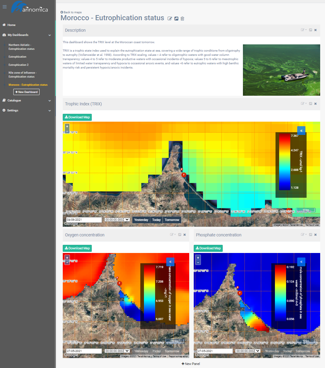
Turning to more specific applications, Sylaios demonstrated the platform’s Web GIS tool kit being developed for mussel farmers, and Lorinc Meszaros of Deltares presented Marinomica’s eutrophication indices and applications.