The EU-funded ODYSSEA project consortium is currently developing a range of value-added, data-based information products to be accessed by end-users via the on-line Marinomica Platform, of which the first two will focus on eutrophication and wave conditions, ODYSSEA partners reported in the recent newsletter.
“These products will give key Mediterranean stakeholders access to information that will help ensure the sustainability of their operations and safeguard the ecosystems, resources and biodiversity of the Mediterranean Sea,” the team commented.
With ODYSSEA’s eutrophication product, end-users will be able to access maps and plots containing daily updates on the trophic state of Mediterranean coastal waters, according to predefined regions. Users will be able to receive information for their specific areas of interest by inserting and selecting various coordinates, allowing them to focus on a smaller area and tailor the product to their own needs.
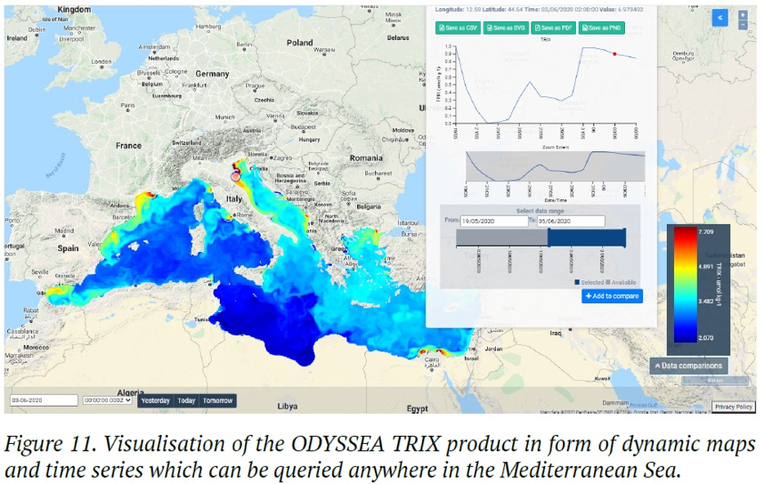
“Eutrophication has serious consequences for the health of marine life and significant economic impacts on local fisheries, aquaculture and coastal tourism,” the project stated, noting that eutrophication can deplete oxygen in the water, leading to marine “dead zones”, and cause large-scale fish kills.
“Knowing where and when eutrophication occurs can help fisheries and aquaculture operators, as well as local authorities and beachside resorts, adapt and respond to minimize negative impacts for human health and their operations.”
ODYSSEA is exploring the possibility of adding a forecast function to the product, as well as an alert system that would notify the user when relevant variables have reached a predefined threshold, making eutrophication likely.
Beyond helping prevent or mitigate damages caused by eutrophication, monitoring the phenomenon also helps in the implementation of marine environmental policies and pollution regulations, they said.
A second package of ODYSSEA products will provide information on wave conditions, including wave power, wave height, wave period, and related atmospheric conditions, such as pressure and winds, in the form of maps, charts, histograms, and key statistics. With these as well, users can select specific areas of interest related to wave conditions in order to receive tailored information.
Wave power information can be of vital use to a range of marine industries and installations, including offshore aquaculture, oil and gas, renewable energy, and ports, the team said. Near-real time and short-term forecasts will allow users to optimise operations and ensure safety, while analyses of past data can inform long-term planning of new installations, such as site selection for wave power plants. Leisure and tourism operators can use individually tailored wave condition information to provide forecasts for recreational activities, including surfing, angling, diving and sailing, and local authorities can make use of the same products to help shape policy and intervention related to coastal erosion, they added.
To ensure that these and other ODYSSEA products continue providing added value after the end of the project, the Consortium is, at the same time, formulating a business development strategy, partners noted.
The update was provided by ODYSSEA partners Laura Friedrich and Helen Klimmek of the United Nations Environmental Programme World Conservation Monitoring Centre (UNEP-WCMC), together with Claire Dufau of Collecte Localisation Satellites (CLS) and Baruch Lionarons of Agora partners.