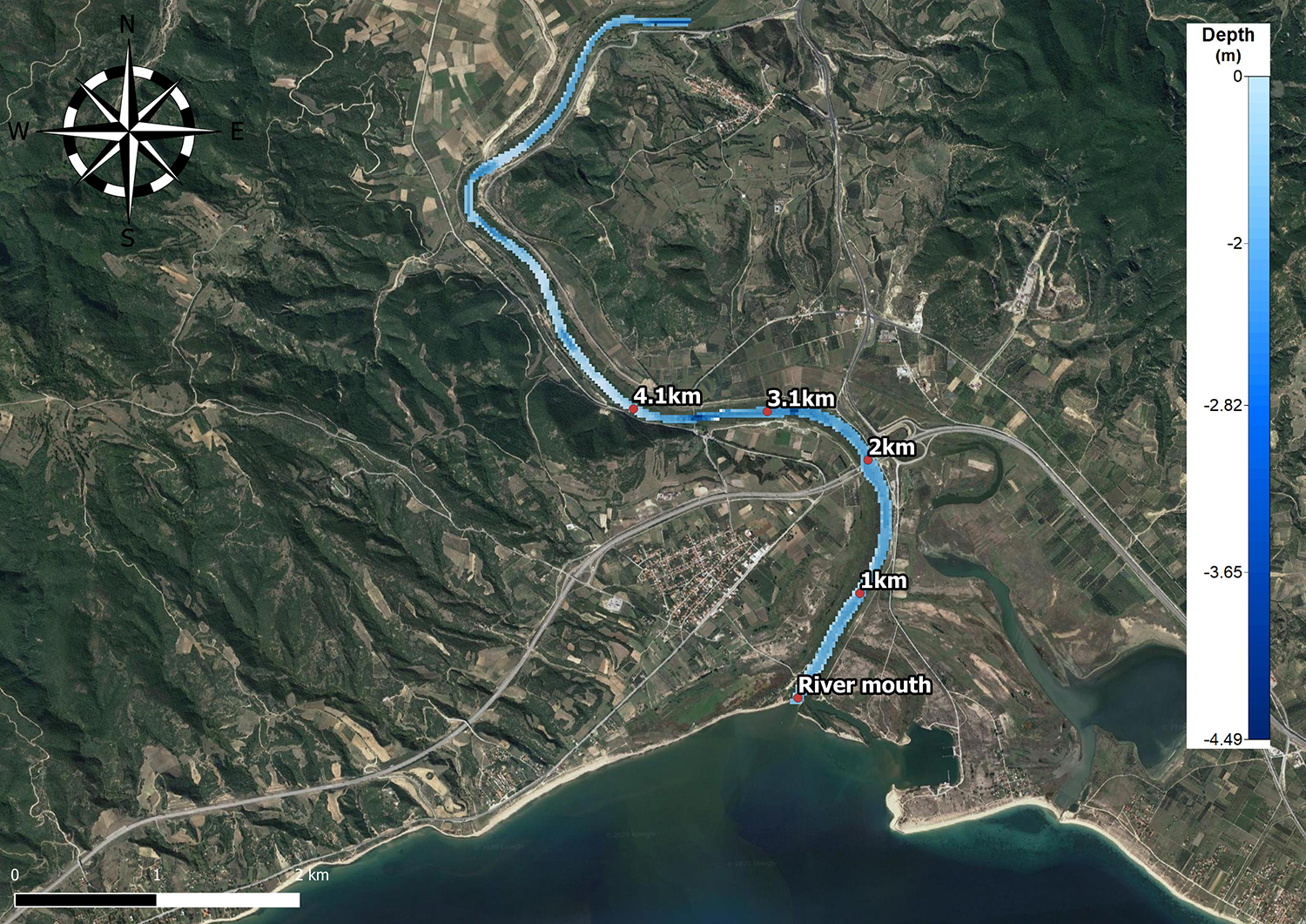
Research partners of the EU-funded ODYSSEA project recently published a study on modelling salt water intrusion upstream in Greece’s Strymon River, which will allow for further development of prediction models and improved decision-making on the part of authorities responsible for managing rivers and estuary regions, as well as adjacent agricultural areas.
The article, titled “Salt wedge intrusion modeling along the lower reaches of a Mediterranean river” was published by Konstantinos Zachopoulos, Nikolaos Kokkos and ODYSSEA project coordinator Georgios Sylaios, all of the Democritus University of Thrace, and appeared in the most recent volume of Regional Studies in Marine Science.
“This research could consist a valuable tool in the hands of local authorities in order to handle the salt water intrusion, reducing the environmental and economic impacts on agriculture when considering the effects of climate change,” the researchers commented. “Understanding the processes controlling the formation and intrusion of this seasonally well stratified salt wedge could lead to the better management of upstream water resources,” they added.
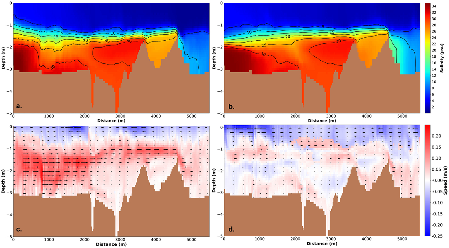
“The salt wedge formation along the lower river mouth triggers a series of adverse environmental effects,” the researchers explained. “The saline wedge intrudes not only longitudinally along the river mouth, but also laterally, salinizing coastal groundwater and degrading nearby aquifers. The long-term isolation of the lower saline layer prohibits the vertical transfer of dissolved oxygen to the bottom stagnant layer. Such event gradually leads to bottom anoxia, deteriorating river water quality. Decline in benthic dissolved oxygen level could be associated with changes in sediment redox and the consequent release of nutrients and trace metals. Additionally, during tidal floods the enhanced bottom velocities of the salt wedge induce local resuspension and suspended matter flocculation, favouring the occurrence of a turbidity maximum at the tip of the wedge. Sudden salt water intrusions, anoxic events and the presence of turbidity maximum at river bottom affect the abundance and distribution of benthic flora and fauna organisms along the river mouth.”
As for their research itself, the team commented that “the main novelty of this study lies in the use of freely-available hydrologic and hydrodynamic data extracted from existing reliable databases (like e-HYPE, CMEMS, TPXO, and NCEP-GDAS), imposed as boundary conditions at the open boundaries of Strymon River lower channel.”
The model’s accuracy is also noteworthy. ““The three-dimensional model applied herein produced fairly accurate results and captured satisfactorily the shape of the arrested salt-wedge in the irregular geometry of Strymon River mouth. Hydrodynamic model results explained adequately environmental issues reacted to salt wedge intrusion, such as bottom anoxia and nutrients and metals remineralization along the river. Model results were used to test theoretical considerations developed for sloped and convergent channels by previous researchers.”
The resulting modelling mechanism is widely transferable, allowing it to be applied more generally by authorities responsible for managing river mouths and similar environments. “This tool could be easily replicable to other estuary environments, with only limitation the accurate bathymetric mapping,” the researchers said.
“These results highlight the need for further studies, especially in the field of operational numerical modeling and forecasting to produce real-time reliable salinity and water flow profiles. Such operational system will have the capacity to respond in any change of external conditions affecting the system, thus leading to proper river management decisions,” they added.
Further research would also potentially apply the model operationally “as a tool for day-to-day salt wedge forecast,” the team proposed.